|


Here's my 29-minute, two-part live narrated video:
http://www.youtube.com/user/NMERider#g/c/71E6C4CBAD4AAE4C
My interactive tracks:
http://www.paraglidingforum.com/leonardo/flight/452444
Bruce's and my igc and kmz files are attached.
[[These are special files needing appropriate programs to view:]]
http://www.energykitesystems.net/Dietch/05-19-2011BBOrd2DesertCntr.igc
http://www.energykitesystems.net/Dietch/2011-05-19_Ord_Indio.igc
http://www.energykitesystems.net/Dietch/2011-05-19_Ord_Indio_+_05-19-2011BBOrd2DesertCntr.kmz
I'd like to thank DanD for suggesting
Ord Mountain as the launch point and
avoiding the 10 Freeway corridor; Wally for driving chase and his wife
Julie for being a good sport and joining our outing; and Bruce for
rescheduling his dental appt with Maynard and being available for 4-wheel,
high clearance transport.
~Tuesday morning the
NAM forecasts for Thursday were showing SW on the
deck by Marshall Peak, clocking around to NW at 15 mph above 6,000'. Tops
were around 9,000' south of the San Bernardino Range and 11-12,000' on the
desert side. Dr Jack's super UniViewer was showing WNW winds of 18-22 mph
all the way to the Arizona
state border with consistent tops of 11-12 k.
Going into Thursday morning, the NAM forecast only improved with one
important exception: The skew-Ts all showed what looked to me like a 2-k
thick cloud deck between 6-8 k along the front side of the range. Out front
where the cloud deck wasn't an issue: the lift just didn't look so good. I
drive a 2-wheel RAV4
with limited ground clearance and street tires. My only
viable option for solo XC was to launch Marshall Peak. Previously, I had
attempted to introduce Wally's lovely bride Julia to the thrills of XC
chase driving, but it turned out to be local fishbowl flying to the
AJX LZ
for me; and Bruce landed my Freedom 170 by the base of Hwy 18 or something
like that. Julie expressed sincere interest and I promised that we would
do this soon and she would be joining us, but only if there were no more than
two pilots.
My original plan was meet Wally and Julie in the LZ at 10:00 a.m. and be
airborne by 12:00 noon having launched from Marshall. Just in case I had
trouble climbing up through an expected hole in the cloud deck I was
equipped with three
GPS units to assist in the task. I planned to fly above the
deck and go
OTB into the desert then make my
east from there. Somewhere
amidst all my XC strategy brilliance and mental foolery, Dan suggested
that I avoid flying anywhere in the valley that the 10 Freeway runs down
as it is known for being, "The Dead Zone" as in no lift.
I sent out my XC spam 'o gram and got a funny reply from Tom who was going
on an epic XC from his house to Fullerton and back. Bruce rose to the
occasion but had dental work scheduled for late in the morning. I did my
best Ron (don't call me Weiner) Keinan-esque Realtor's pitch as to why he
needed to reschedule his dental work and fly with me instead. I even offered
to let him borrow my
Freedom 170, which he'd previously flown XC. Bruce
capitulated to my arm-twisting tale of how we'd fly wing-in-wing from
Marshall to Blythe, and drop in on 'Drummer Stan'. That soon became Ord-to-Blythe as Dan (Ah shucks I have to work) told me to tell Bruce we needed
to launch Ord and fly the north side of the Berdoo range all the way to
the end before shadowing the 10.
The time pressure was off, as there was no reason to get airborne prior to
1 PM and the day should allow us to go on final glide into sunset. We were
now talking about up to 6 good hours of lift with a 20 mph tailwind. That
certainly makes a 155-mile flight possible even though the tops were only
11-12 k. "Just think of 3-400 mile flights from Zapata, TX at 4 k AGL", I
mentioned to Bruce.
The drive up the
BLM road to Ord was so gnarly that it made the road up to
Blackhawk seen like the road up to Marshall. Bruce suggested that next
time we include Herb in our XC plans just to get him out of his hermit
cave. For those unacquainted, Herb is reputed to have more 100-mile
flights than anyone in the state. I understand that he used to fly an
ATOS,
supine.
We arrived at launch a little past 12:30 and it was blowing straight in,
but gusting 10-25 mph and switchy. There were definite cycles and clouds
forming upwind. Base appeared to be around 8-9 k when we first arrived at
this 4800' launch. Somewhere near the top of our drive, Bruce talked about
the day Herb flew roughly 2.5 miles while Bruce made a very gentle low
save over the high school that began with near-zero sink and gradually
strengthened as he rose and eventually flew over 300 miles for the state
HG distance record. One thing I love about Bruce is his subtle way of
motivating me through his clever needling tactics. Works for me every time
too.
I got setup and launched at 13:09. I did a radio check with Wally and it
did not go well. I assumed the problem was on Wally's end and not mine.
Bad move on my part. I had a damaged wire in the molded pigtail of my
headset due to the frequency with which I yanked it out to silence the
various noise when flying Sylmar. I must have had 250 hours on this
headset too. Each time I flew, I get more pops and breaks while
transmitting--and never bothered to put in a fresh one, which I had in my
ditty bag in the truck.
My other major pre-launch f-up was not eating anything with
protein. I had a
light breakfast and did not request we stop for a burger anywhere on the
way up because I was impatient. Bruce had a half-Subway sandwich he would
have donated; and that would have added several good hours onto my
flight. I don't like to mooch excessively and ate three Trader Joe's oatmeal raisin cookies that
I brought which gave me
insulin crash about an hour later. Part of the
reason I was cursing up a storm was from not eating properly. I became
rather irritable to say the least. I did well at King Mountain in 2010, in
part, because I ate a big steak breakfast most mornings. On the days I just
ate pancakes instead, I did not perform as well. This has been generally
true for me over several hundred hours of flying in varied conditions.
This is getting boring. On with the flight already!
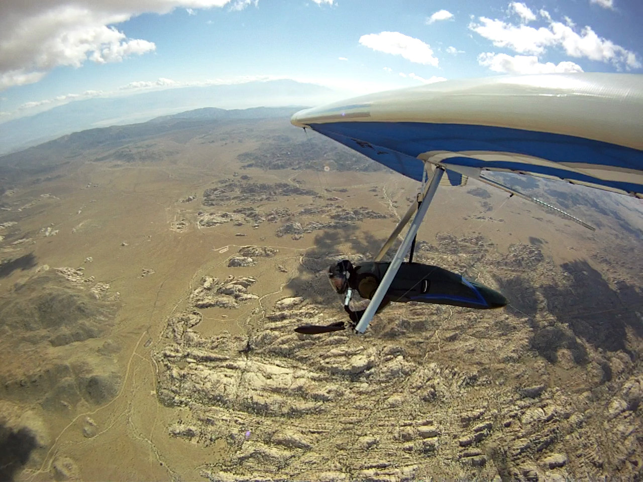
I launched and turned in the first thermal I found, then drifted behind
launch and got chewed up and spit out. This went on for three iterations
and rapidly because tiresome. I finally flew out front toward the path of
an approaching cloud and sure enough I found a workable
thermal that got
me up. Rather that flying back upwind and doing that again and hitting
cloud-base level I elected to go OTB at 8,000' even though I was well below
cloud base. Prior to launch, Wally suggested I let Bruce launch first and
show me the lift. I respectfully declined, stating that I needed to get
the jump on Bruce in his rocket ship Atos VR.
Initially I flew down the north side of the range, but I kept getting my
ass handed to me. It was so miserable I just wanted to land and drive
chase. Did I mention Bruce's story about Herb's 2-1/2 mile flight? I saw
the Mitsubishi cement plants to the east and recalled these as excellent
thermal spots thanks to Wally's excellent coaching on a previous Blackhawk
flight. Sure enough, I caught nice one a mile or so west of the
western-most plant. I called on radio to Wally and somewhere around this
time Bruce announced he's at 10,200' above launch. I cursed and swore I
would not give Bruce any fodder with which to needle me. I did the only
logical thing and headed north out over the
Lucerne Valley and left behind
the mountains and the turbulence. I told myself, "If I can't work from
scratch then I don't know how to fly XC", as I looked down upon the
Lucerne Valley and tried to pick out the house of 2-meter radio operator,
Ron who has kept me company on many flights over both sides of the range.
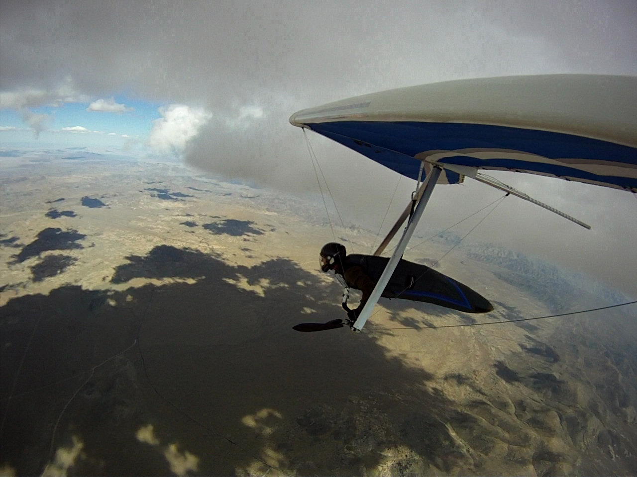
And 'scratch' was all I had to work with too. There biggest cloud streets
were either 20+ miles north or on the south side of the
SB mountain range.
I spotted some poorly marked lift lines that were defined by small clouds
but nothing downwind of me. I recalled the lessons of
Bill Soderquist who
told be he could spot a convergence line by subtle difference in the
transparency of the air or by line of dust devils along the surface. I had
no such skill or visual acuity but I was highly motivated and there was
this small line of little clouds. Did I mention Bruce's story about this
Herb fellow?
I drew a mental extrapolation line along the ground that followed the line
of the clouds up wind. Not only did this eventually work, but it got me
caught up with Bruce at the 62-mile mark. Only I didn't know he was only
1/4-mile away and had visual on me. I kept waiting for Bruce to buzz me at
some point during our flights and my bad radio contact should have
motivated him. It was at this juncture that I elected not to continue east
along the morth side of the range. I had also gotten only bits and pieces
of Bruce's transmissions to Wally and I believed that Bruce was near the
10 Fwy. and that I needed to be on the south side of the range too. There
was this excellent cloud street that would have taken me all the way to
the Salton Sea had I remained on the
north side. I was tired, hungry and
very bitchy due to lack of fuel in my system and decided to play it safe
by crossing the Little San Berdoo Mountains from what turned out to be the
LEE SIDE!!!
That's not playing it safe, but I did make it over with about 1200' to
spare. Once on the other side I did find a good thermal that brought me
back up high enough that I felt comfortable proceeding east. Did I mention
that Dan said something about a 'Dead Zone'? And not the one that had
firmly established itself between my ears. Sure enough it was dead, save
for the, you guessed it--the cement plant! What is it about cement plants
that attracts thermals? I just don't know but they sure do deliver. This
may have been a quarry or a mine but it's all the same to me. The dead
factor won the battle of the lapse rate, and I knew I needed to find a
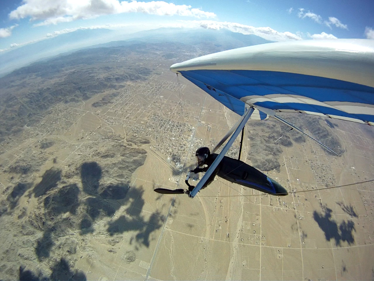
place to set down and grab some chow. I turned west and told Wally that I
was at the 77-mile mark and heading for a shopping mall. It turned out to
be a pair of truck stops on the Coachella/Indio border but there'd be
food.
Initially I glided upwind into pretty buoyant air and was maintaining a
good glide angle from about 3800' or so. As I got lower, my glide angle
rapidly deteriorated. By this time my camera batteries had died although
my voice recorder was still very much alive. I spotted a huge, smooth
field that looked to be part of a little-utilized trailer park. Initially,
I was going to play it safe and set down there, but realized that I may have
a long wait before getting picked up, and opted to beat my way upwind
toward the truck stops. I scrutinized this 480-acre undeveloped lot from
afar and could see that it was being used as a garbage dump but also
looked as though it was somewhat cleaned up. Winds were getting pretty
gusty--as I got lower-- and they were switchy too. I determined the mean wind
direction by noting my lateral-drift fluctuations and put her right down
the middle. This path happened also to be the 'Valley of the Broken
Mirrors'!
Did I happen to mention about my irritability and cursing? I did not call
this zone in the field by any such aforementioned euphonium. But I
digress. All that profanity got edited out of my Good Housekeeping Seal
Approved video. As I am sure you have heard by now. I am of course
assuming that at least one of two of my readers has even gotten this far
before hitting his/her wastebasket icon. Upon making a safe and clean
landing in the shithole I was referring to, I immediately began hand
flying my glider for about 200' until I found a clearing where I could
break it down. Oddly the winds on the very surface were so smooth (did I
mention 'The Dead Zone'?) that I could fly my
T2C 144
with good tension on
my harness bridle and easily steer it while I jogged my way upwind.
I was promptly greeted by none other than 'Glenn, the Wheel Polisher'.
Glenn came up to me and introduced himself as the resident transient who
has been camping in this field for the past 2 years. He and his
SO make
their living by polishing rims for various and sundry truckers and motor
vehicle owners who frequent the turnaround and the other truck stops. Glenn
proudly showed me the aluminum oxide that accumulated under his nails and
cuticles as he offered me his Top Ramen soup in a styrobowl that he
recently made. Glenn even offered me his back-wash free and mostly full
bottle of Dr. Pepper. Did I mention about the burger I never stopped to
pick up and eat?
There's a lot more to this story and I haven't even gotten warmed up yet,
as one may imagine. Suffice it to say that Julie is now an enthusiastic
partner of Wally when there are no more than two pilots on the XC
adventure. Bruce and I compared notes at the
Denny's near his house in Berdoo and
found it interesting that we crossed paths having taken completely
different routes and with the aid of clearly defined cloud streets. We
also concluded that had my radio been working right (my bad) we could have
team-flown from the 62-mile mark eastward and could have flown a very long
distance together. Bruce admitted that he had the
Colorado River in his
sights but opted to turn back and land at Desert Center facilitate my
retrieval, and save on mileage costs. My share of the 350 miles on Bruce's
truck plus Wally's driving wasn't cheap. We figured ~$0.60/mile split two
ways. Hopefully, the next time there will be at least four of us on the truck
and everyone will be well-fed and have his radio system working well.
I'm confident that Julie will join me on local XC flights using my
cheaper-to-run RAV4.
Cheers,
Jonathan
|